The 4 best Helvellyn walks that you need to know about
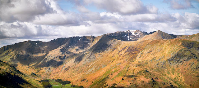
Helvellyn is one of the most popular Laker District mountains to walk and for good reason - on a good day the views are incredible and if you like walking along ridges then Striding Edge is one of the best ridges in the UK and Swirral Edge is pretty awesome too! Most people who walk to Helvellyn start from either Glenridding or Patterdale, but you can also start from the western Thirlmire side too!
Below are the top 4, most well-known Helvellyn walking routes, and for any first timer to the Lake District - I would recommend one of these well-trodden walking routes. I've provided screenshots of the Helvellyn map routes and also linked to the full interactive OS maps that you can zoom in on. If you've never done Helvellyn before - I thoroughly recommend going via Striding Edge first (provided the weather is favourable ie. not wet or icey). Striding Edge en-route to Helvellyn is one of the best walks in the UK, never mind the Lake District, and pretty safe if you walk with care and in good weather conditions. But all 4 of these Helvellyn walking routes are great for various reasons as outlined below and I've done them quite a few times now.
 |
| Read on to discover the 4 best Helvellyn walking routes, but first here are answers to the most common questions about Helvellyn |
Helvellyn questions answered:
How high is Helvellyn?
Helvellyn is 950m in height and is the 3rd highest mountain in England after Scafell Pike (978m) and the nearby Sca Fell (964m).
How long is the walk up to Helvellyn?
To climb to Helvellyn it will take anywhere from 5 to 7 hours. It depends where you start form and which route you take. The 4 best Helvellyn routes are listed on this page below.
Is Helvellyn OK for beginners?
Striding Edge can look imposing - but in good, dry weather conditions the walk is ok for beginners if you have walking experience and a good level of fitness and don't mind using your hands on occasions to scramble the summit. Beware though it can be dangerous on Striding Edge in wet or winter conditions.
Is Helvellyn a hard walk?
Helvellyn is a challenging walk, it's the 3rd highest mountain in England, so you have to be comfortable with heights and be fit. It's difficulty also depends on which route you take. Read on to learn about the 4 best routes.
Plan your Helvellyn Walk with OS Maps :
It would be foolish to walk anywhere in the Lake District without maps and to help plan your Helvellyn walks, I really recommend the Phone Map App by Ordnance Survey. You can download the route maps below to your phone and the app will show you exactly where you are on the route even when you have no signal - so you'll keep on track the full length of the walk and won't take any wrong turns (which is easy to do!) Click the banner below to find out more.
 |
ROUTE #1.
Helvellyn Walk from Patterdale, via Striding Edge, Swirral Edge and Red Tarn
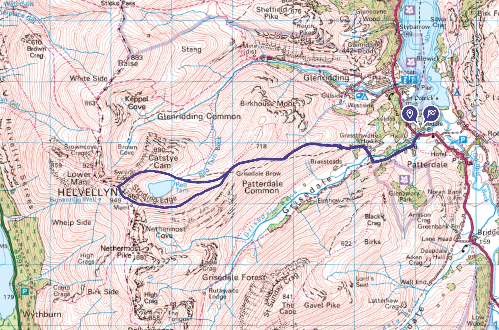
This Helvellyn walk is the shortest Striding Edge route and a simple route to follow from the small village of Patterdale (it can be modified to start from Glenridding also). You start by heading up to Helvellyn via Grisedale Valley towards the 'Hole-in-the-wall' (literally just a gap through a wall haha, but a good place to stop and have a snack) and then you'll head onto Striding Edge to the summit of Helvellyn. You'll descend via Swirral Edge and the shores of Red Tarn. You then simply then re-trace your steps after passing by the 'Hole-in-the-wall', back to Patterdale for a simple end to the walk. I'd probably recommend this simpler, shorter route for first-timers who want to tackle Striding Edge & Swirral Edge but have a quicker return route where the going is easier on the legs!
To modify and extend this walking route to start from Glenridding (where there is more parking spaces), head west a little out of Glenridding towards Gillside campsite and then take the path to the south of Birkhouse Moor in Little Cove that follows the side of Mires beck. Once near the summit of Birkhouse Moor - head to the Hole-in-the-wall and then onto Striding Edge, Helvellyn and descend via Swirral Edge.
Helvellyn Walk Distance: 7.11milesHelvellyn Walk time: 4.5 hoursHelvellyn Walk difficulty: Difficult (scrambling required)
ROUTE #2.
Helvellyn Walk from Glenridding, via Striding Edge, Swirral Edge and Catstye Cam
This longer Helvellyn route is my personal favourite as it's the most exhilarating and perfect for those who love a challenge. You will box off all the highlights of Striding Edge, Helvellyn, Swirral Edge and Catstye Cam, and give you a variety of stunning views. Its one of the best walking challenges in all the Lake District.
You start from Glenridding, head into Grsidedale Valley via Lanty's Tarn and then walk up to Striding Edge and onto Helvellyn. You return via Swirral Edge & then onto the summit of the striking Catstye Cam, with a descent into Glenridding Common for different views on the return leg.
HELVELLYN WALK ROUTE 2 MAP:
Helvellyn Walk Distance: 7.78milesHelvellyn Walk time: 5 hoursHelvellyn Walk difficulty: Difficult (scrambling required)
ROUTE #3.
Helvellyn Walk from Thirlmire
This Helvellyn walk from Thirlmire is a good one to try if you want something a little bit different from the Striding Edge route, or simply want to avoid Striding Edge! The route from Thirlmire is the quickest and shortest walk to the summit of Helvellyn - but therefore quite steep from the off and a bit of an uphill slog. You will though get fine views of Thirlmire that you can't get if you walk from Glenridding side. It's definitely a route to try out - but for your first time I would recommend the Striding Edge route. However in winter conditions when Striding Edge is a bit dangerous - then this would be an excellent route to try and the views of the surrounding Lake District fells will be incredible.
HELVELLYN WALK ROUTE 3 MAP:
Helvellyn Walk Distance: 5.80 milesHelvellyn Walk time: 4 hoursHelvellyn Walk difficulty: Hard
ROUTE #4.
Helvellyn Walk, long route from via Grisedale, Dollywagon Pike and Nethermost Pike
If you want to increase the distance or avoid the ridges then this Helvellyn walk (which can be done from Glenridding or Patterdale) is a grand day out. You'll get a lot of variety on this Helvellyn walk and bag a few Wainwrights tooo! You walk up Grisedale Valley towards Grisedale Tarn and then onto Dollywagon Pike, Nethermost Pike and to the summit of Helvellyn. Returning via Lower Man and above Keppel Cove down into Glenridding Common. It's a long route at 11.5 miles, but great if you have the time.
HELVELLYN WALK ROUTE 4 MAP:
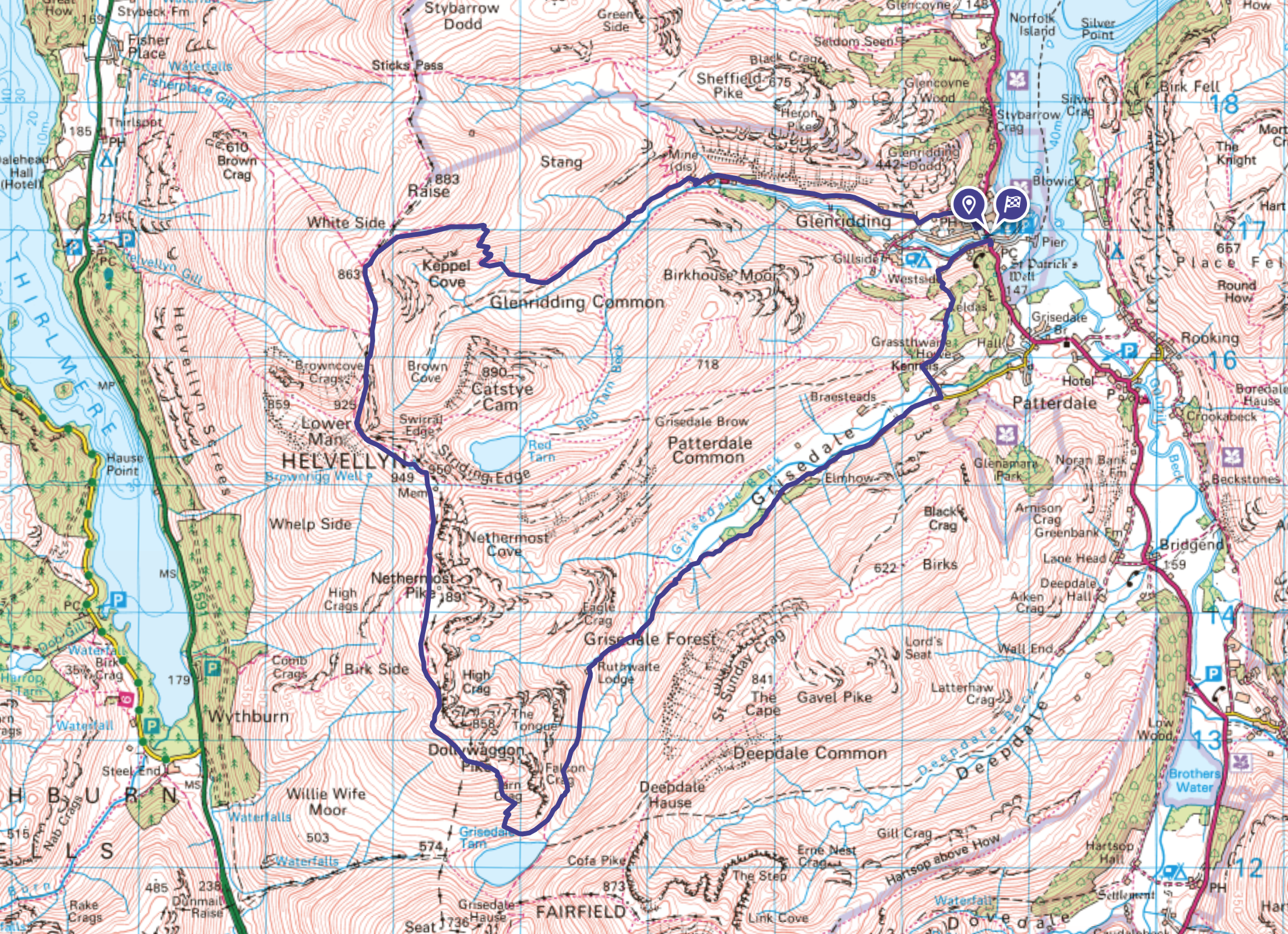 |
| A Helvellyn walk that's perfect if you want to increase the walking distance for a grand day out! |
Helvellyn Walk Distance: 11.52milesHelvellyn Walk time: 6-7 hoursHelvellyn Walk difficulty: Hard
So there you are - that's my 4 best Helvellyn Walks and if you've never done Helvellyn before then they should help you in planning your walk to Helvellyn - one of the Lake Districts best mountains!
As mentioned, if you don't have a Phone Map App - I really recommend the one by Ordnance Survey to download the routes above to your phone to keep you on track every step of the way even when you have no phone signal.
 |
Happy Hiking!

Post by Stuart Hodgson 'The Hiking Photographer'

I hope you've enjoyed the blog and it helps you to plan a trip! I share my adventures as I'm passionate about the physical & mental health benefits the great outdoors brings to us and I want others reap these positive effects too!
You can subscribe to my email newsletter to stay up to date with all my recent outdoor adventures, including my latest photos & blog posts, just click the link below!
FOLLOW ME
Not all my adventures & photos end up on this blog -
Give me a follow on social media to see what else I've been up to!
 |
| If you have found my blog useful and you'd like to send a token of appreciation - you can now buy me a beer to enjoy after a hike by clicking here - cheers! |







Thanks for taking the time to put this post together. I'm hoping to hike Helvellyn this weekend and will probably go with route #2 for the change of scenery on the way back down, compared to route #1 which retraces the same path. Cheers!
ReplyDeleteI'm pleased you have found it useful. Route 2 is superb - I hope you get the weather and clear skies as the views are superb. On your descent you can always decide whether to do Catstye Cam or not depending on how you feel! Best of luck with your Helvellyn walk
ReplyDeleteThis was so helpful. I did route 2 yesterday using the os map app and absolutely loved all the scrambling! Sadly no views from the summit of hellvelyn and catstye but the clouds/mist made striding edge look even more exciting!
ReplyDeleteIt's a great walk isn't it - that Helvellyn route is perfect for scrambling and glad you enjoyed it. I've probably only been able to see off the summit of Helvellyn half the time I've been up there so the views aren't guaranteed haha - walking in the mist gives it a whole different feel - at least it wasn't raining!
ReplyDeleteHi sadly I couldn’t do striding edge as I have problem with knee and couldn’t really scramble and felt I did not have the adequate balance. Is there less of a scramble on route 4
ReplyDeleteWent up Hellvelyn via Striding Edge (Route 1) on 4 June. The weather was sparkling. The views were incredible. A fantastic experience. Flexible climbing shoes are better suited to this walk than trekking shoes.
ReplyDelete